The beautiful dawn view from the balcony of the Brewarrina Hotel disguised the storms that were brewing.
With rising morning sun shining over my shoulder, conditions were right for an early start on the 1200km ride home.
The rest area by the Bogan River in Nyngan is the perfect stop for a roadside breakfast. The decorative post showing the height of major floods that have hit Nyngan.
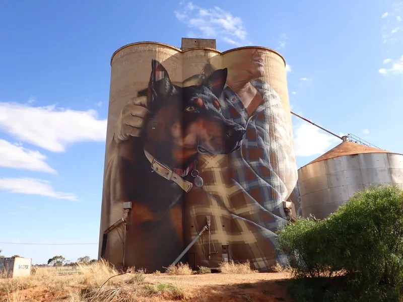
Painted grain silos are a well-known feature of the North Western Victoria, in the big river country, there is a water tower art trail.
It was a nice dry 700km ride to Nerrandera and a comfy room at the Historic Star Lodge. It is a beautiful historic building with many of the original features.
And a view over the township from the balcony.
The last stop on the central plains of NSW was the small Riverena town of Urana.
The diarama of sheep, shepherd, and horse at the southern end of town is a unique piece of street art.
The picnic area on the lake is the perfect place for barrista made coffee for morning tea.
Across the Murray River, I was soon in North East Victoria, on the edge of the Australian Alps, in the cool autumn air of the King and Goulburn River Valleys.
It was an easy run home through the hills to end a little 11 day tour out to the edge of the outback.
"See here, young man," said Mulga Bill, "from Walgett to the sea,
From Conroy's Gap to Castlereagh, there's none can ride like me.
From “Mulga Bill’s Bicycle” by Banjo Patterson.
I like stopping at the towns and villages recounted in the early Australian balads.
The flood plains of the Namoi River were full of water.
In the “land of drought and flooding rain” therehe had been a flooding monsoon north in tropical Queensland a couple of months earlier. The flood waters were slowly moving south, bringing vital water to the edge of the Outback as it travels thousands of kilometres to the Murray River, which empties into the Southern Ocean.
Wallgett was just a photo stop as my destination was Lightning Ridge, famous for its Opals.
Lightning Ridge is very much more a tourist town rather than a prospecting these days. Especially if compared to the Opel prospecting South Australia, Coober Pedy, and Blinman.
There are some good aspects to a tourist town….
The street art…
The Opal shops…
Even fine coffee with delicious apple strudel and ice cream.
Lightning Ridge sits on the Great Artesian Drive, a series of thermal baths drawing water from Australia’s Great Artesian Basin.
It was hot 30c in Lightning Ridge so I enjoyed the cold water of the campground pool to the hot spa.
My next stop was Brewarrina and little detour to Goodooga for a hot bath in the cool of the morning.
I arrived at the Aboriginal Cultural Centre in Brewarrina for the last cultural tour of the day
Brewarrina sits where the northern rivers come together to form the Darling River, which funels the monsoon rains of the tropical north of Australia southward along the edge of the Outback, providing precious water to a dry land.
Drone photo by Dave Kelly
Brewarrina, which means Tall Trees, was/is a special meeting place for Aboriginal Australians. The rock fish traps pictured above were built over 10,000 years ago. And were an intrcately designed so that fish could be caught and stored in ponds.
This photograph (below) from 1870 shows aboriginal children collecting fish from the fish traps.
Photo in Aboriginal Cultural Centre.
The banks of the Darling River also contain ochre, which is used for skin care and decoration by aboriginal people.
White ochre on the river bank.
Unfortunately, the high state of the river had covered fish traps. But a river full of water is something beautiful in itself.
And on the river bank, I spied some some red tailed black cockatoos. A beautiful bird that lives along the rivers on the edge of the outback.
From Brewarrina, it was time to follow the river flow south toward home.
On the road to Sea Lake there is the little settlement of Nullawil with its beautifully painter silo.
This is the eastern most point on the Victorin Silo Art Trail. The trail covers around 700km of the Wimmera Mallee region and includes 13 painted silos.
As this was only a short trip I can only offer a sample of the artwork.
Nullawil
Sea Lake
Sea Lake has some beautiful street murals as well.
Heading south west from Sea Lake the village of Lascelles has the next painted silo.
Then running south there is Roseberry
Then Brim, the first of the silos to be painted and completed in 2016
The last silo on this trip was in Rupanyap.
As you can imagine this is grain growing country. Mainly wheat but also other grains and pulses.
At Murtoa, there is ‘the stick shed’. A huge grain storage shed with a floor space of 1.5 ha and the roof held up by massive poles or sticks.
There were many of these sheds built around Australia in the 1940s but this is the last surviving “stick shed”. It’s a wonderful piece of Australian national heritage.
Sea Lake is a small village in the Mallee Country in the North West of Victoria. It gains its name from the salt lake next to it.
It was a great opportunity to take my faithful old mighty Moto Guzzi Breva 1100 for a run.
Lake Tyrrell whose name is derived from the aboriginal word Deril which means open to the sky. It is Victoria’s largest salt lake that is believed to be formed 120,000 years ago.
The lake is a a light pink colour.
The thin film of water over the lake provides a mirror like finish and perfect reflections.
The outback sunset was just an amazing sight reflected on the lake.
The Lake is also a great place for star gazing and practising astronomy watching the endless sky of the outback.
Unfortunately the building cloud cover that added drama to the sunset made star shots not possible. But what a view this beautiful lake provided.
The Murray and Darling rivers converge at Wentworth. These rivers form the Murray – Darling Basin which is an area important for both food production and environmental diversity.
The Murray starts in the Australian Alps near Mount Kosciusko fed by snow melt and Alpine rain. The Darling is fed by the monsoons of northern Australia. In the photo you can see the muddy water of the Darling in the foreground as it mergers into blue water of the Murray.
I camped 20km down stream of the rivers junction on the banks of the Murray.
Beside the Murray River as it slowly rolls south west to the Southern Ocean around 500km away.
In many ways the Murray forms the southern boundary of the Outback or at least the southern east corner of the hot dry lands that are the outback.
I had ridden up from a cultural holiday in Adelaide and this was the first stop on the edge of the outback that would lead me to Mungo National Park (my next stop) then up the Darling to Bourke (previous post).
Leaving the banks of the Murray it was onto the dirt roads to get out to Mungo National Park – A World Heritage area.
It was hot and I was happy to set up my tent under a shady tree
The Park was once sheep station and the old shearing shed a relic of those times.
Mungo National Park has both colonial and aboriginal history. The colonial history goes back a century or so. The aboriginal history is an over 46,000 years continual association with the land.
This long association was confirmed with the finding of the remains Mungo Man and Mungo Lady. These remains that have been dated as 46,000 years old. These are the oldest homosapian remains found on the Australian Continent. These are also some of the oldest examples of ritualistic burial any where in the world. If you want more information follow this link: https://learn.culturalinfusion.org.au/story-of-mungo-man-and-mungo-lady/
Another feature of Lake Mungo is the sand dunes that stretch for 135km across the horizon like the walls of China, but nature made.
Areas of dunes are called Lunettes because of the luna type landscape. But in these dunes are artefacts tens of thousands of years old.
At sunset the dunes tale on a redish hue as the sun burns the sky orange and red.
That night I slept with wonderment of the place and what a tiny spec modern humanity is on the universe while sleeping under the milky way.
In the morning I did a tour of the dunes with an aboriginal ranger. As part of the tour I help artefacts 10,000 years old and heard stories of the land, this place that had been passed down from generation to generation in the oldest continuous culture in the world. Stories and rituals that had their origin back 46,000 years ago.
As I left Lake Mungo there was a Sand Goanna on the side of the road.
I thought it was wishing me a fond farewell but, looking back, I think that it was a sign that the 350+km of dirt road I had before me to get to Bourke was going to be a difficult and sandy ride.